
Photography
You’re most likely a city bumpkin and will find yourself going gaga over the views on day 1 itself. Unless the misfortune of bad weather befalls you, each day offers uniquely great sights, and will be colder than the last, so keep your pants on. This is all the more important if you’re the sort of traveler who doesn’t plan well and aren’t carrying enough charge or storage. Depending on the extent of your poor planning, you might run out of supplies or die midway so factor that in against your conservation efforts.
The descent has significant overlap with the ascent which provides you the option to click pictures of some of the stretches on your way back. By then you would have made your peace with being tired. You should have also become better at picking scenes which bring out the fancy quote in the foreground and cover pictures candidates which capture your vibrant, philosophical, spontaneous, tranquil personality. The selfie that goes on your DP is most likely going to be the one you take at the top so don't bother until then.
Survival
You won’t die. Remember to stay hydrated, especially if you’re on the altitude sickness pill. There are plenty of streams to replenish your water canteens from but remember to filter any leeches out before you gulp some down. Don’t eat too much though because mid-trail toilet breaks which involve squatting are tricky to pull off and it’s unlikely that Modi’s policies will get there before you do. The nice looking berries are usually the poisonous ones.
Don’t buy a hiking pole, but buy the slightly expensive shoes; there is plenty of free bamboo to be found on the trail but almost no spare footwear. The mobile coverage is next to none so stay on the trail and carry playing cards. If you’re bad with basic instructions and directions then additionally bring flares and satellite phones.
When the instruction tag says the rucksack should rest on your hips, it means, within your own specific anatomic constraints, horizontally and not vertically. Pack it in a way that the items you’ll need to put in or pull out while walking are easy to access. You don’t need a towel as much as Douglas Adams would have you believe. In fact, your comfort with a lack of hygiene and tolerance to cold weather decides how light your bag will be. Don’t be one of those ladies from period English movies and offload three big, heavy bags for someone else to take care of. If toddlers can carry their school bags, you can carry yours too.
Performance Anxieties
If you’re feeling very proud of carrying your own bag, you want to look away from the group of over-enthusiastic east Europeans who are carrying their supplies and equipment as well but, in your defense, are much bigger than you. Your trek leader will likely be the same size as you yet he / she will be fitter, stronger, and faster than you multiple times over. That's because they have training and a degree in hiking. The porters and the joes who, all of them combined, aren't dressed in as much hiking gear as you are, will frequently overtake you and make it across in a third of your time. They grew up here and are genetically built for the mountains so one shouldn't expect anything lesser. The joes will, almost symbolically, defecate anywhere with scant regard for the beauty of the place or the amount of money you paid for this trip. Swallow your pride and always remember - the slower you are, the lesser distance it is downhill in case of medical emergencies or natural disasters.
The joes, by the way, are the yaks, but apparently they aren’t yaks, they are joes. It isn’t the easiest of strings to get a quick and correct Google result for so I have no idea how it is actually spelt or what exactly they are but since neither people named Joe nor mugs of coffee make an appearance in this post, I don’t expect it to cause much confusion.
Campsites
The camp sites can be small clearings on a cliff, or vast valleys. You will typically be sharing them with other groups and management isn’t responsible for your valuables. If you are lucky, the ground below your tent might be even. Worse than uneven ground though is sloping ground because the person at the foot of that slope is going to get crushed by others over the course of the night. Any semi-permanent or permanent toilet sheds on the trail are public property, and are maintained in a manner one expects from that model of ownership. A worthy alternative is usually present as a small tent with a hole dug up in the ground that your hiking staff set up. Toilet paper is usually bio-degradable and can be dumped in the hole. The bag hanging inside the tent is probably to fold up and carry the tent in and not to dump used toilet paper in. The extra hand made available by a head lamp, a feature that a torch doesn’t readily offer, is highly useful.
Transportation To and From Yuksam
Depending on your port of entry, the hiking group will likely help you organise transportation but this is business and they will take a cut out of it. There are many taxi operators listed online so if you can coordinate with three to five other hikers and one of the operators you could bring down the cost by a bit. There also are public shuttle services which would be much cheaper, and also a great way to get close to some of the locals. The people seemed honest and straightforward despite their nationality so it's unlikely you will be pickpocketed or groped. Do unto others as you want them to do unto you, Delhi-ites.
Day 1, Yuksam to Bhakim, 5600 feet to 8600 feet
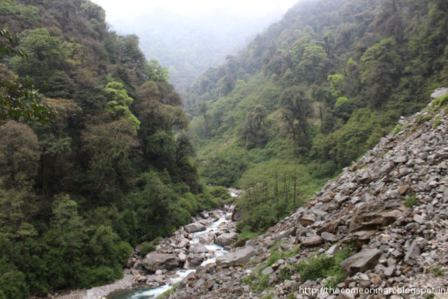
Day 1 is mostly long hours of patient walking on slightly sloping terrain during which you will cross four bridges and an unmanned police post where you’re supposed to present identification, maybe for them to find volunteers for periods of low official supply. The difficult part only begins after you lose significant altitude to reach the fourth bridge of the day, and it comprises of recovering all that altitude and more. This will be a stern evaluation of your fluid replenishment strategy and shortcomings will be punished with severe cramps on the way up and through the rest of the evening.
Day 2, Bakhim to Tshoka, 8600 feet to 9700 feet
Day 2 is the lightest day of the trip. The day you had get to the airport or the train station to board your ride to Sikkim would be tougher. You wake up, you have your first breakfast in the mountains, you put on your boots, and you arrive at Tshoka. It offers you a great view of the valleys you just left behind and is the last spot with a any mobile coverage. Walk around the lake as you go higher to acclimatise and grab a bowl of Wai Wai on your way down back to camp. It's the only instant noodles brand that doesn't kill you in a manner the government disapproves of.
Day 3, Tshoka to Dzongri, 9700 feet to 12980 feet
On the heels of the easiest day, is the toughest day. It would seem this is by design because the toughest day doesn't offer a break point in between which the easy day can be stretched to. It's long and almost all uphill which facilitates spooking the newbies with stories about altitude sickness and death. The camp is set on a picturesque piece of flat land surrounded by mountains and, all in all, is not a bad spot to die. You can climb up to one of the tops the next morning and get some amazing views of the sunrise and the local celebrtiy, Khangchendzonga, amongst the other commoner peaks.

Day 4, Dzongri to Thansing, 12980 feet to 12900 feet
The toughest day is followed by the most beautiful day of the entire trip, starting from the morning climb up the peak to catch the sunrise, to the very scenic walk for the rest of the day including the possible detour to Lakshmi Lake in between. Lunch is at Kokchurang, a beautiful rocky spot in the middle of the gushing Prekchu river. There is a significant descent to reach the lunch site, which can be hard on the knees. It is additionally covered with plenty of loose rocks, occasionally making it hard on the bottom.
Day 5, 6th May, Thansing to Lamuney, 12900 to 13600 feet
Day 5 is a bit like day 2 except it's the eve of the big day. You're supposed to take your acclimatisation seriously and be in bed by 6 so that you can push off by 2 in the morning to reach Viewpoint 3. Temperatures below 0 can be expected and snowfalll could pour cold water on your plans restricting you to only Viewpoint 2 or Viewpoint 1 even.
Acclimatisation will involve hiking up to Samiti Lake, which you might be misled to believe would be a vast span of turqoise surrounded by mountains. Beyond those mountains lies Viewpoint 1, and the rest of them. Save enough charge in your phone to play the soundtrack from The Hobbit the next day as you cross these peaks.

Day 6.0, 7th May, Lamuney to Viewpoint 1, 13600 feet to 15000 feet
We could only reach Viewpoint 1, so I can't speak for what's after that. The terrain after Samiti, like Darth Vader, is cold, hard, and barren with low oxygen levels. Nevertheless, a frozen trail is better than a wet one. Take a break and savour the accomplishment of getting your out of shape body all the way till here. The hard part is over.

Day 6.5, 7th May, Lamuney to Thansing, 13600 feet to 12900 feet
The descent starts on the same day itself. You head back to Thansing right after returning from viewpoint 1. Expect celebratory games of dumb charades, poker, antakshari, etc. Your protests or confessions to lack of skill or knowledge will be futile. If you hate these games, remind yourself you only have to put up with it for two more days anyway.
Day 7, Thansing to Tshoka, 12900 feet to 9700 feet
The path of return takes you through a forest, a stark change from the mountains and open skies from the other days. It stretches on for much longer than your patience lasts and after multiple hopeful bends that unravel in disappointment, you emerge at Phedang again, which you might remember from lunch on day 3. From there on, you just need to retrace your steps.

Day 8, Tshoka to Yuksam, 9700 feet to 5600 feet
Amble along at a leisurely place. It's unlikely you'll get lost and even if you do, you should be able to find mobile network or yell loud enough for someone who isn't lost to hear you. Put on a look of wisdom and wordliness for all the other trekkers going in the other direction. Don't look tired or let the dull ache everywhere make itself known. When they ask how it was, talk about your soul and use adjectives and verbs from beauty product advertisements. You have internet again so start replying to everything you got in the last few days and posting things on FB and Twitter apologetically mentioning that you didn't have internet connectivity in the mountains where you were trekking at 15000 feet and how it felt great to be disconnected and sleeping under the stars in mother nature's cradle, etc. Keep it subtle.
There are only two restaurants in Yuksam so you don't have much of a choice for the evening but, if you haven't already, you need to start thinking about what you're doing between Yuksam and catching your flight / train / bus. For those without specific plans, think of it as a reunion with long lost friends like a bed, AC, pizza, etc. and make it special.
Day 10
Start work on the blog post as soon as the trek is over. The longer you take, the lesser your trekking group remembers you, and the lower the number the nostalgic or courteous likes and shares you can harvest.
Day 25
By the time your blog post has moved down on the timeline the weight loss would be kicking in and you'd have something to be cheerful about. Some of the people who haven't asked you about your Himalayan adventure yet might ask you about your weight loss and you have a chance to score a few more hits on that blog post.
Day 30
Change your social network pictures another month later to squeeze out the last hits.
Day 45
Start a Joes of Sikkim page along with the others from your group.
Day 75
Resign from your job and join a start up so that you can write a post about why you quit.
You’re most likely a city bumpkin and will find yourself going gaga over the views on day 1 itself. Unless the misfortune of bad weather befalls you, each day offers uniquely great sights, and will be colder than the last, so keep your pants on. This is all the more important if you’re the sort of traveler who doesn’t plan well and aren’t carrying enough charge or storage. Depending on the extent of your poor planning, you might run out of supplies or die midway so factor that in against your conservation efforts.
The descent has significant overlap with the ascent which provides you the option to click pictures of some of the stretches on your way back. By then you would have made your peace with being tired. You should have also become better at picking scenes which bring out the fancy quote in the foreground and cover pictures candidates which capture your vibrant, philosophical, spontaneous, tranquil personality. The selfie that goes on your DP is most likely going to be the one you take at the top so don't bother until then.
Survival
You won’t die. Remember to stay hydrated, especially if you’re on the altitude sickness pill. There are plenty of streams to replenish your water canteens from but remember to filter any leeches out before you gulp some down. Don’t eat too much though because mid-trail toilet breaks which involve squatting are tricky to pull off and it’s unlikely that Modi’s policies will get there before you do. The nice looking berries are usually the poisonous ones.
Don’t buy a hiking pole, but buy the slightly expensive shoes; there is plenty of free bamboo to be found on the trail but almost no spare footwear. The mobile coverage is next to none so stay on the trail and carry playing cards. If you’re bad with basic instructions and directions then additionally bring flares and satellite phones.
When the instruction tag says the rucksack should rest on your hips, it means, within your own specific anatomic constraints, horizontally and not vertically. Pack it in a way that the items you’ll need to put in or pull out while walking are easy to access. You don’t need a towel as much as Douglas Adams would have you believe. In fact, your comfort with a lack of hygiene and tolerance to cold weather decides how light your bag will be. Don’t be one of those ladies from period English movies and offload three big, heavy bags for someone else to take care of. If toddlers can carry their school bags, you can carry yours too.
Performance Anxieties
If you’re feeling very proud of carrying your own bag, you want to look away from the group of over-enthusiastic east Europeans who are carrying their supplies and equipment as well but, in your defense, are much bigger than you. Your trek leader will likely be the same size as you yet he / she will be fitter, stronger, and faster than you multiple times over. That's because they have training and a degree in hiking. The porters and the joes who, all of them combined, aren't dressed in as much hiking gear as you are, will frequently overtake you and make it across in a third of your time. They grew up here and are genetically built for the mountains so one shouldn't expect anything lesser. The joes will, almost symbolically, defecate anywhere with scant regard for the beauty of the place or the amount of money you paid for this trip. Swallow your pride and always remember - the slower you are, the lesser distance it is downhill in case of medical emergencies or natural disasters.
The joes, by the way, are the yaks, but apparently they aren’t yaks, they are joes. It isn’t the easiest of strings to get a quick and correct Google result for so I have no idea how it is actually spelt or what exactly they are but since neither people named Joe nor mugs of coffee make an appearance in this post, I don’t expect it to cause much confusion.
Campsites
The camp sites can be small clearings on a cliff, or vast valleys. You will typically be sharing them with other groups and management isn’t responsible for your valuables. If you are lucky, the ground below your tent might be even. Worse than uneven ground though is sloping ground because the person at the foot of that slope is going to get crushed by others over the course of the night. Any semi-permanent or permanent toilet sheds on the trail are public property, and are maintained in a manner one expects from that model of ownership. A worthy alternative is usually present as a small tent with a hole dug up in the ground that your hiking staff set up. Toilet paper is usually bio-degradable and can be dumped in the hole. The bag hanging inside the tent is probably to fold up and carry the tent in and not to dump used toilet paper in. The extra hand made available by a head lamp, a feature that a torch doesn’t readily offer, is highly useful.
Transportation To and From Yuksam
Depending on your port of entry, the hiking group will likely help you organise transportation but this is business and they will take a cut out of it. There are many taxi operators listed online so if you can coordinate with three to five other hikers and one of the operators you could bring down the cost by a bit. There also are public shuttle services which would be much cheaper, and also a great way to get close to some of the locals. The people seemed honest and straightforward despite their nationality so it's unlikely you will be pickpocketed or groped. Do unto others as you want them to do unto you, Delhi-ites.
 |
| Avoid heavy meals on your way to Yuksam or back. |
 |
| The Gandalf of horses. |
 |
| Outside this monastery there was a complaint book for visitors. It probably feeds right into their sales leads database |
 |
| Shameless Indian dogs. Rolling over, and singing, and dancing for white people. |
 |
| One day, a Bron-Y-Aur Stomp will emerge from this house. |
 |
| How to play tug of war in an area half the length and twice the breadth. The teams could also use chains, batons, and kicks on each other. Rope rash, I'm going to call it. |
 |
| You can check out any time you like? |
 |
| ★★★★☆ We came across this small tea shop next to the RIP Homestay on our way down from the monastery. We aren't tea connoisseurs but we don't mind the occasional drop. The tea was okay. It needed more sugar which we had to ask for and add ourselves. The service was okay. The staff was friendly. The prices were low. The ambience was nice. A Jenga set, some board games, some magazines, wi-fi, dull yellow lights, charging points, bean bags, and lots of other people staring into their laptops with their big headphones on would improve this place multi-fold. I would recommend this tea stall to my friends if they don't mind a place which serves tea without the right amount of sugar but has friendly staff, low prices, and nice ambience. |
 |
| While it's beautiful and all that, I'm sure there are other buildings that Yuksam would find more useful than a temple. Like a bar with a foosball table, for example. |
 |
| The prediction interval of any time series I've ever forecasted. Yellow is historic. Red is future. |
 |
| There's a park and a lake somewhere near the place where there is a throne. I have no memory of what the name of any of those things are. It started raining and we had to rush back, otherwise I'd probably remember. |
Day 1, Yuksam to Bhakim, 5600 feet to 8600 feet
Day 1 is mostly long hours of patient walking on slightly sloping terrain during which you will cross four bridges and an unmanned police post where you’re supposed to present identification, maybe for them to find volunteers for periods of low official supply. The difficult part only begins after you lose significant altitude to reach the fourth bridge of the day, and it comprises of recovering all that altitude and more. This will be a stern evaluation of your fluid replenishment strategy and shortcomings will be punished with severe cramps on the way up and through the rest of the evening.
 |
| Trekking is like reading Ayn Rand. The distance to displacement ratio is extremely high. |
 |
| Bridge no. 1. The first of many. The trek has just started. You can still see people posing and smiling. |
 |
| Once Gandalf became the white one, someone else had to don the gray. Also, why do horses have there jaw joint jut out so much? Is James Milnerinvolved somehow? |
 |
| This is the view from bridge no. 4. The next happy sight is when you reach camp. |
Day 2, Bakhim to Tshoka, 8600 feet to 9700 feet
Day 2 is the lightest day of the trip. The day you had get to the airport or the train station to board your ride to Sikkim would be tougher. You wake up, you have your first breakfast in the mountains, you put on your boots, and you arrive at Tshoka. It offers you a great view of the valleys you just left behind and is the last spot with a any mobile coverage. Walk around the lake as you go higher to acclimatise and grab a bowl of Wai Wai on your way down back to camp. It's the only instant noodles brand that doesn't kill you in a manner the government disapproves of.
 |
| That small orange tent on the far right, just next to the edge, is the toilet. Not that you have a choice, but Bakhim is a good place to get used to navigating in the dark with a flashlight. |
 |
| When there's only one cookie left. |
 |
| The seeds of a plant pride parade have been sown. |
 |
| The next day's journey comprises of getting over those hills in the background. The shed on the right are the toilets. Don't be fooled by how quaint it is on the outside. |
 |
| The sites in Tshoka include the temple (top right) which the Buddhist authorities visit and bless once a year, and a cafe, located between the temple and the camp site, that serves Wai Wai soup and Hit beer. If a member of the blessing cavalcade stops for a bite at the cafe, the cafe serves old monk. |
 |
| While the trek is supposed to be a very romantic trek, the mountains also offer a great opportunity to play farthest-wins sort of weeing competitions. |
 |
| Saturday nights. |
 |
| Tshoka could use some werewolves. |
Day 3, Tshoka to Dzongri, 9700 feet to 12980 feet
On the heels of the easiest day, is the toughest day. It would seem this is by design because the toughest day doesn't offer a break point in between which the easy day can be stretched to. It's long and almost all uphill which facilitates spooking the newbies with stories about altitude sickness and death. The camp is set on a picturesque piece of flat land surrounded by mountains and, all in all, is not a bad spot to die. You can climb up to one of the tops the next morning and get some amazing views of the sunrise and the local celebrtiy, Khangchendzonga, amongst the other commoner peaks.
 |
| Their parents weren't okay with the differences so they ran away to Sikkim. When the parents discovered the two had left, they exclaimed, "Doggone it!", and everyone had a good laugh. |
 |
| Do plants have feelings? Here's one that's clearly very irritable given how easy it is to get under its skin. |
 |
| Apart from werewolves, some unicorns, some elves, leprechauns, and dwarves would also add a lot to the trip. |

 |
| Don't drop anything that isn't worth going all the way to the bottom to recover. |
 |
| We were all eating our lunches while this Russian lady sat in her Firefox hat waiting for her friends to show up at the entrance. Treks have so little to offer by way of food indulgence that I felt like a Flipkart consumer by day 3. Aapki har wish hogi puri aloo. |
 |
| Once virtual reality is cheap enough, this setting would make for a good drunk test. |
 |
| It might snow. Memorise the area, in case you have to make a dash for the toilet in the night. |
Day 4, Dzongri to Thansing, 12980 feet to 12900 feet
The toughest day is followed by the most beautiful day of the entire trip, starting from the morning climb up the peak to catch the sunrise, to the very scenic walk for the rest of the day including the possible detour to Lakshmi Lake in between. Lunch is at Kokchurang, a beautiful rocky spot in the middle of the gushing Prekchu river. There is a significant descent to reach the lunch site, which can be hard on the knees. It is additionally covered with plenty of loose rocks, occasionally making it hard on the bottom.
 |
| I have a feeling the whole it's-darkest-before-dawn thing is hokum. Coldest, maybe. Not darkest. The early bird has enough light to spot a worm, but at the risk of catching a cold. |
 |
| A clear glass bowl with vanilla and cookie ice cream, some knife work, a few raisins, a bed sheet, and low, overhead lighting and you can make your own mountain scene at home. Furthermore, you don't have to wait six days after that to eat some vanilla and cookie ice cream. |
 |
| Lick vanilla and cookie clean. Replace with brownies and vanilla or frosting. More knife work. Change angle of lighting. |
 |
| If this was Pocket Tanks, these guys would be screwed. |
 |
| There are two small stores here, both privately held by the same family. They are a retail monopoly in these parts. All they need is an app and they are on their way to becoming unicorns. |
 |
| I should have tried to convince him to turn around and hold my hand while I take the picture. |
 |
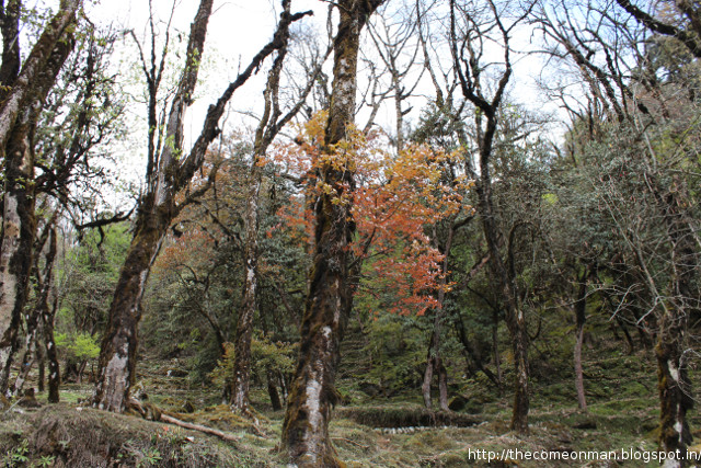
| Over the previous day and this one, you transition from a dense green cover to the slightly more arid stretches. I call it the menopause stretch. |
 |
| Just to give you an idea of how far ahead the rest of them were while some of us clicked pictures and some of us caught our breath |
 |
| This is on the detour to Lakshmi lake. The lake itself was surrounded by quite a bit of snow and there was a snow fight going on, settings in which the camera is better kept inside. |
 |
| This heap of stones is apparently a cremation chamber. Do high altitude residents get an unfair advantage at getting to heaven? |
 |
| If you keep going along the river you might find a gravitational singularity. |
 |
| It's basically a bunch of rocks that get washed down with a river or glacier and fit within each other. It is a fun and challenging stretch of jumping from on rock to another like one of the middle levels from Dave before the shooting things show up. |
 |
| I assume that stream rises during summer making the bridge more useful than just a device to avoid getting the soles of your likely waterproof shoes wet. |
 |
| Rock beats scissors. Scissors beat paper. Paper beats rock. Water beats everything. Become like water. |
 |
| This is actually much darker than the picture looks like. I was doing fancy DSLR things to get the stars. |
Day 5, 6th May, Thansing to Lamuney, 12900 to 13600 feet
Day 5 is a bit like day 2 except it's the eve of the big day. You're supposed to take your acclimatisation seriously and be in bed by 6 so that you can push off by 2 in the morning to reach Viewpoint 3. Temperatures below 0 can be expected and snowfalll could pour cold water on your plans restricting you to only Viewpoint 2 or Viewpoint 1 even.
Acclimatisation will involve hiking up to Samiti Lake, which you might be misled to believe would be a vast span of turqoise surrounded by mountains. Beyond those mountains lies Viewpoint 1, and the rest of them. Save enough charge in your phone to play the soundtrack from The Hobbit the next day as you cross these peaks.
 |
| There isn't enough oxygen for proper trees to grow here. Yet here we are, without an oxygen mask. Congratulations on our evolutionary victory. We showed 'em. |

 |
| When Mars had water. |
 |
| Miles to go before I sleep. Miles to go after I get up. 67% of the options playing out in the partner's head during Miles Davis' one night stands. |
 |
| The lake is just at the edge of the mountain ahead. If everything goes right, you'll be climbing it at 4 in the morning the next day. |
 |
| It would be rather unfortunate if a landslide or avalanche were to occur after you made it all the way here. |
Day 6.0, 7th May, Lamuney to Viewpoint 1, 13600 feet to 15000 feet
We could only reach Viewpoint 1, so I can't speak for what's after that. The terrain after Samiti, like Darth Vader, is cold, hard, and barren with low oxygen levels. Nevertheless, a frozen trail is better than a wet one. Take a break and savour the accomplishment of getting your out of shape body all the way till here. The hard part is over.
 |
| This is the view from Viewpoint 1. Somewhere in the distance, behind something maybe, are Viewpoints 2 and 3. |
 |
| We were in a hurry on our way up so all my pictures are from on our way down. |
 |
| You can also spot some sort of deer apparently. |
 |
| That isn't turquoise, right? You could try and ask for a refund at this point. |

Day 6.5, 7th May, Lamuney to Thansing, 13600 feet to 12900 feet
The descent starts on the same day itself. You head back to Thansing right after returning from viewpoint 1. Expect celebratory games of dumb charades, poker, antakshari, etc. Your protests or confessions to lack of skill or knowledge will be futile. If you hate these games, remind yourself you only have to put up with it for two more days anyway.
Day 7, Thansing to Tshoka, 12900 feet to 9700 feet
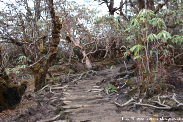
The path of return takes you through a forest, a stark change from the mountains and open skies from the other days. It stretches on for much longer than your patience lasts and after multiple hopeful bends that unravel in disappointment, you emerge at Phedang again, which you might remember from lunch on day 3. From there on, you just need to retrace your steps.
 |
| These frozen things on the ground are called something. They are extremely brittle so want to keep your clumsier friends away until you've clicked all the pictures you wanted. |
 |
| Unless you have remarkably good balance, you are unlikely to get very good pictures of it yourself anyway |
 |
| Camp sites are often vulnerable to aerial attacks. They are almost completely immune to naval threats though. |
 |
| Where your local photo studio got its background drapes from. |
 |
| The forest bit stretches out for so long that nobody would judge you if you swung your arms and made machete and lightsaber noises as you walked through the dense foliage. |
 |
| On the left is a drawing of the route drawn on some sort of skin or leaf. People might ask you to take their pictures with it while they point to various spots on it. Battery excuse works on the way up. Figure out something on your way down. |
 |
| Our staff got this delicious cake somehow. I don't know if there was an oven in the kitchen shed or whether a cake delivery start up conveniently happened to be aggressively expanding its market. |
 |
| That's Rohit in the centre. I've never met anyone who gets as excited or happy at pouring out the morning tea. Bob is on the right. He's called Bob because of Marley. He's the dude on this trek. He laughs a lot. For reasons. I'm sorry, chap on the left. I don't remember your name. |

Day 8, Tshoka to Yuksam, 9700 feet to 5600 feet
Amble along at a leisurely place. It's unlikely you'll get lost and even if you do, you should be able to find mobile network or yell loud enough for someone who isn't lost to hear you. Put on a look of wisdom and wordliness for all the other trekkers going in the other direction. Don't look tired or let the dull ache everywhere make itself known. When they ask how it was, talk about your soul and use adjectives and verbs from beauty product advertisements. You have internet again so start replying to everything you got in the last few days and posting things on FB and Twitter apologetically mentioning that you didn't have internet connectivity in the mountains where you were trekking at 15000 feet and how it felt great to be disconnected and sleeping under the stars in mother nature's cradle, etc. Keep it subtle.
There are only two restaurants in Yuksam so you don't have much of a choice for the evening but, if you haven't already, you need to start thinking about what you're doing between Yuksam and catching your flight / train / bus. For those without specific plans, think of it as a reunion with long lost friends like a bed, AC, pizza, etc. and make it special.
 |
| Mate bait. |
 |
| Just so you know, I do not ask people to pose. |
 |
| Every time there's an argument, I propose the parties wear wet socks while they are fighting. Make them step into 12 inches of water every few minutes so that the socks can't dry. They get dry socks only after they've settled. Watch how fast quarrels are resolved. |
 |
| Trekking needs a fashion revolution. |
 |
| At the end of a long, hard... |
 |
| ...trek, all sorts of relationships are forged. |
 |
| Even the wildlife gets in on some of the action. |
 |
| You need battery only for one more day so you are allowed some frivolities. Refer picture with leaf and window. |
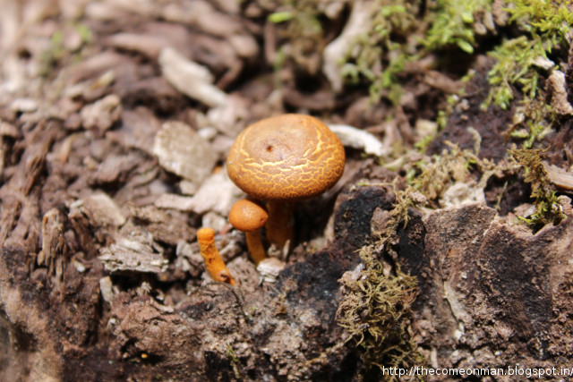 |
| Mushrooms also get stretch marks. |
 |
| This is the gastonia of the mushroom world. |
 |
| Artsy closing picture. |
Day 10
Start work on the blog post as soon as the trek is over. The longer you take, the lesser your trekking group remembers you, and the lower the number the nostalgic or courteous likes and shares you can harvest.
Day 25
By the time your blog post has moved down on the timeline the weight loss would be kicking in and you'd have something to be cheerful about. Some of the people who haven't asked you about your Himalayan adventure yet might ask you about your weight loss and you have a chance to score a few more hits on that blog post.
Day 30
Change your social network pictures another month later to squeeze out the last hits.
Day 45
Start a Joes of Sikkim page along with the others from your group.
 |
| "This bridge is like dental braces. An elaborate system of wires keeping up a bunch of metal plates." "That's too literal. You understand the concept of a metaphor, right?" "Yes, I do. Sorry." "No problem. Try again." |
 |
| "My job to carry your things. I take pride. No, not pride. How you say...? Herd! Pride is lions. I take herd." |
 |
| "We've been at odds since way back. We want tents and sleeping bags too but they don't give us any. It's terribly hard to throw a rock or swing a stick with hooves so they always win in the end." |
 |
| "Boo! Haha. I made a pun. Haha." |
 |
| "My girlfriend was cheating on me so I shot her down. Shot her down down. They would have hanged* me to die back there if I hadn't escaped to the south. India is a safe haven for bovine fugitives. |
 |
| "Click a tasteful nude of me. I don't want any crass stuff, okay?" "Like one of my French girls?" "I don't know how good a photographer your French girls are but okay, whatever." |
Day 75
Resign from your job and join a start up so that you can write a post about why you quit.
Day 200-something**
It isn't joe, it's Dzo
* edited on 21st. I was incorrectly using hung. Thanks Shivaram NV.
** Jojo, one of the studdest people to have graduated out of IITM according to Quora, found this.
No comments:
Post a Comment